

Daknor AS, Nustadkroken 5, 3970 Langesund - post@daknor.no - Telefon Kai 4000 6340, Torfinn 944 72 749.

Med en vanlig handholdt GPS
kan du måle inn punkt og linjer.
Nøyaktigheten kan ligge ned mot 3-5 m.
For 1-10 cm nøyaktighet, bør du ha en landmålings GPS, Promark, Trimble, TopCon, Leica eller lignende.
Hvis du vil vite mer om Promark GPS kan du kontakte f.eks. www.rektangel.no
Pass på at gps'en kan eksportere og importere gpx.
Hvis GPS'en kan importere og eksportere dxf, trenger du ikke dette plugin for å lese dataene inn i TurboCAD.
Gi meg gjere tilbakemelding om du har testet dette med en landmålings gps, eller målebok.
(ring Kai tlf. 4000 6340)
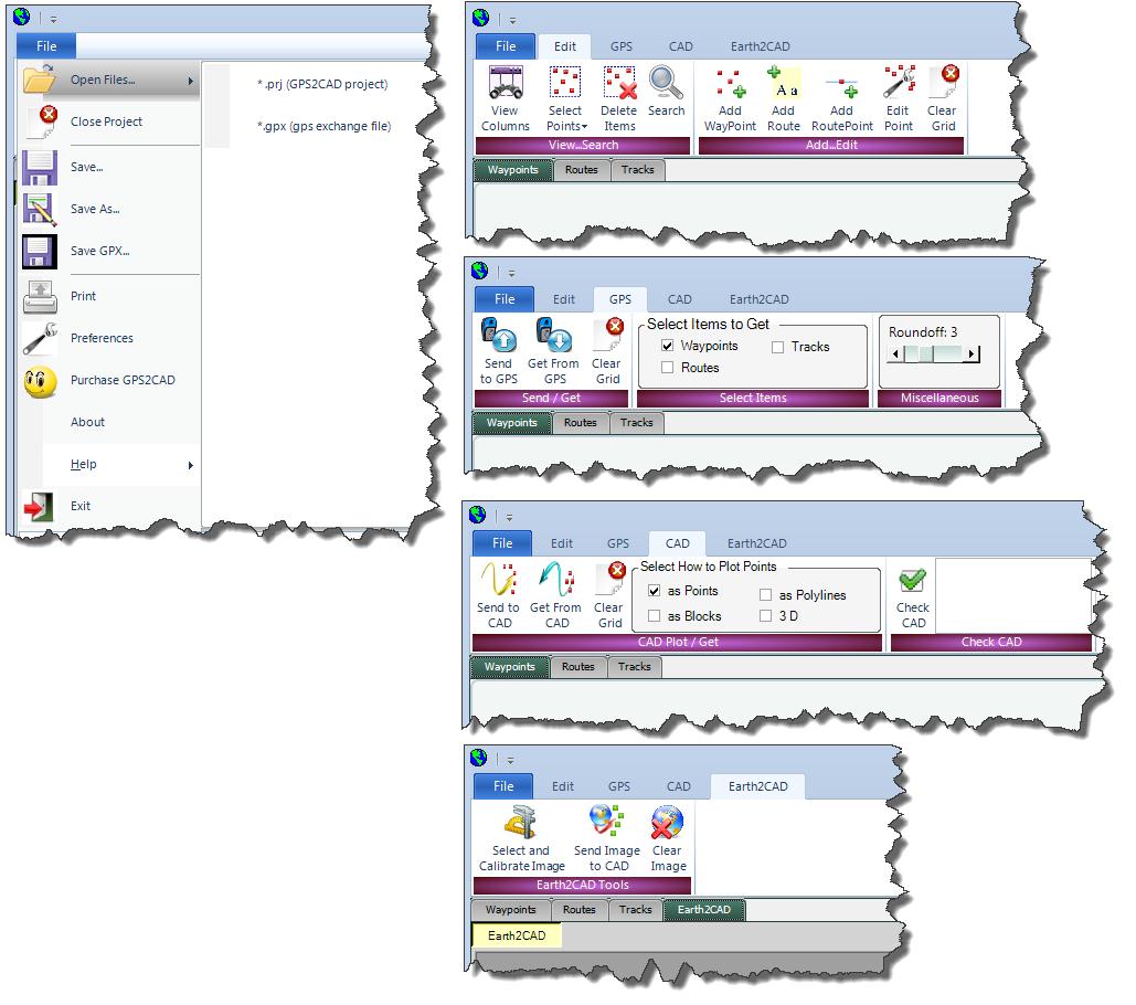
For å kunne overføre data til og fra GPS og TurboCAD, anbefaler jeg programmet GPS2CAD.
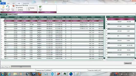
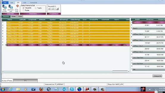
Under ser du noen skjermdump, og to tester som viser at der virker.
GPS2CAD koster 295 USdollar, (ca. kr. 1657)
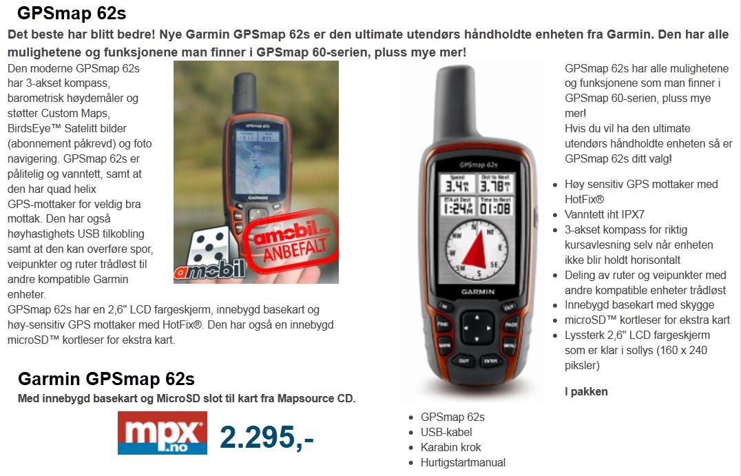
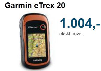
Garmin GPSMAP 62S ca. kr. 2300.
kan du måle inn punkt og linjer.
Nøyaktigheten kan ligge ned mot 3-5 m.
For 1-10 cm nøyaktighet, bør du ha en landmålings GPS, Promark, Trimble, TopCon, Leica eller lignende.
Hvis du vil vite mer om Promark GPS kan du kontakte f.eks. www.rektangel.no
Pass på at gps'en kan eksportere og importere gpx.
Hvis GPS'en kan importere og eksportere dxf, trenger du ikke dette plugin for å lese dataene inn i TurboCAD.
Gi meg gjere tilbakemelding om du har testet dette med en landmålings gps, eller målebok.
(ring Kai tlf. 4000 6340)
For å kunne overføre data til og fra GPS og TurboCAD, anbefaler jeg programmet GPS2CAD.
Under ser du noen skjermdump, og to tester som viser at der virker.
GPS2CAD koster 295 USdollar, (ca. kr. 1657)
Garmin GPSMAP 62S ca. kr. 2300.
GPS2CAD is GPS software that gives design professionals major cost savings in data collection by using recreational-grad GPS units to collect field information and plot it in TurboCAD, DoubleCAD, and AutoCAD.
Most recreational GPS units are well-suited for site layout and “topo-plotting” requirements that do not need great accuracy, and GPS2CAD bridges the gap between these GPS units and CAD. GPS2CAD lets you easily bring your GPS points into your CAD environment. At the click of a button you can plot polylines, points, and blocks that show your GPS points. The points can be plotted in 3D for use in terrain modeling, and the blocks carry attributes showing all the point data.
Here’s just a few of the features:
Plots the waypoints in TurboCAD, DoubleCAD, and AutoCAD
Runs in Windows 7, 64 bit environment
On-line help that always provides the latest information
Works with most Garmin GPS units
Works with newer GPS units that work as mass storage devices
Works with .gpx file formats, the GIS industry standard.
Provides Datum Translation
GPS2CAD translates the GPS points into more than hundreds of worldwide coordinate systems, including the extremely popular NAD 27, NAD 83, and the State Plane Coordinate systems (used in the United States).
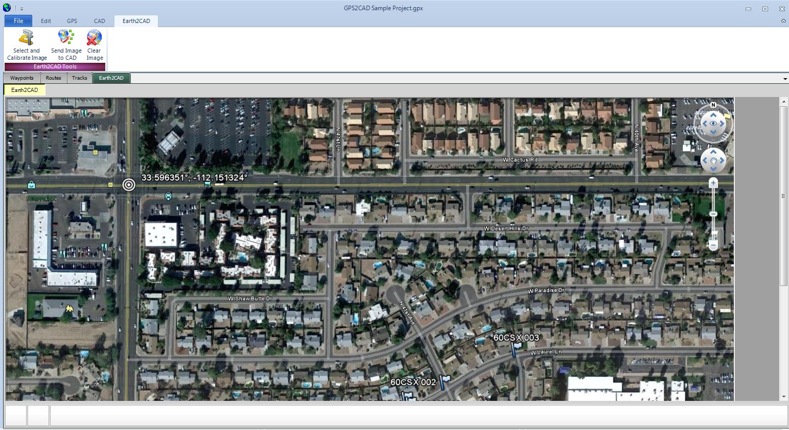
Earth2CAD
This important feature allows you to import geographic bitmap images from popular mapping programs such as Google Earth. The image can be scaled and then sent into your CAD program, so you can plot your GPS points and draft over it.
Compatible with Windows 7
GPS2CAD has been completely upgraded to work with Windows 7, 64 bit platforms, which host most of today’s CAD programs. In addition, it works with the latest versions of AutoCAD, TurboCAD, and DoubleCAD.
Most recreational GPS units are well-suited for site layout and “topo-plotting” requirements that do not need great accuracy, and GPS2CAD bridges the gap between these GPS units and CAD. GPS2CAD lets you easily bring your GPS points into your CAD environment. At the click of a button you can plot polylines, points, and blocks that show your GPS points. The points can be plotted in 3D for use in terrain modeling, and the blocks carry attributes showing all the point data.
Here’s just a few of the features:
Plots the waypoints in TurboCAD, DoubleCAD, and AutoCAD
Runs in Windows 7, 64 bit environment
On-line help that always provides the latest information
Works with most Garmin GPS units
Works with newer GPS units that work as mass storage devices
Works with .gpx file formats, the GIS industry standard.
Provides Datum Translation
GPS2CAD translates the GPS points into more than hundreds of worldwide coordinate systems, including the extremely popular NAD 27, NAD 83, and the State Plane Coordinate systems (used in the United States).
Earth2CAD
This important feature allows you to import geographic bitmap images from popular mapping programs such as Google Earth. The image can be scaled and then sent into your CAD program, so you can plot your GPS points and draft over it.
Compatible with Windows 7
GPS2CAD has been completely upgraded to work with Windows 7, 64 bit platforms, which host most of today’s CAD programs. In addition, it works with the latest versions of AutoCAD, TurboCAD, and DoubleCAD.
Prøveversjon Prøveversjonen har inge begrensninger i tid, men tillater kun 4 punkt.
3 filmer på YouTube som viser gps2cad
http://www.youtube.com/watch?v=T3kQLL-A6aM
http://www.youtube.com/watch?v=bHfd9QognP8
http://www.youtube.com/watch?v=UCXSqHYDaJ0
3 filmer på YouTube som viser gps2cad
http://www.youtube.com/watch?v=T3kQLL-A6aM
http://www.youtube.com/watch?v=bHfd9QognP8
http://www.youtube.com/watch?v=UCXSqHYDaJ0
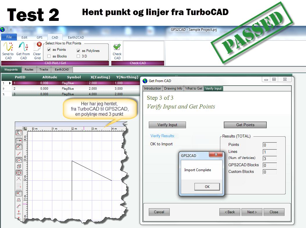
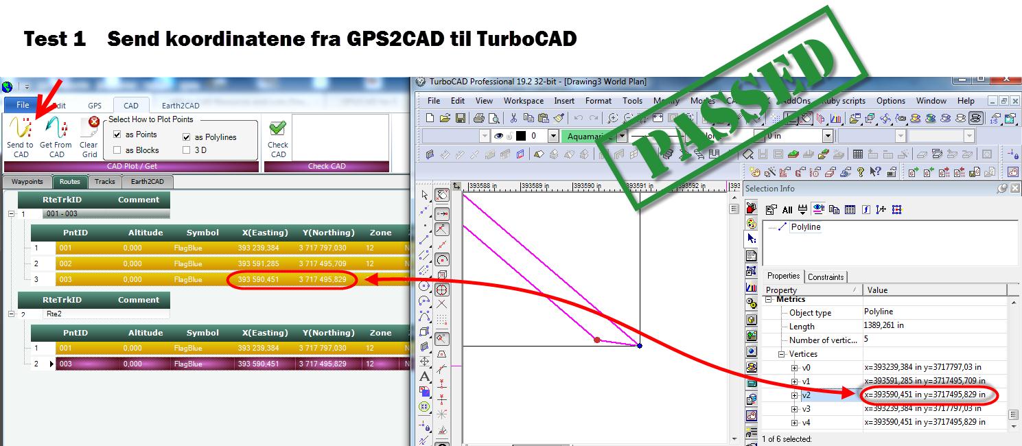
Her har jeg gjort 2 tester på overføring til og fra GPS2CAD og TurboCAD19
GPX for handholdte GPS
DXF for Landmmålings GPS
DXF for Landmmålings GPS
http://www.youtube.com/watch?v=J6_bEt9G7Ow&list=PL53A8AEE683C995BF&index=1

Min første test
av programmet
19 desember
Ser ut til å være
meget vellykket.
Les her her
av programmet
19 desember
Ser ut til å være
meget vellykket.
Les her her